Thursday 22 August - serious riding begins. Mulbekh to Lamayuru - 65 km comprising a 500 metre climb followed by 400 metre descent, then 700 metre climb to 4100 metres (13,500 feet), the highest point on the Srinagar-Leh highway, then a descent to 3500 metres, our sleeping altitude for the night. The first climb averaged about 4.5%; The second climb was longer but mostly not as steep at about 3.5%.
The scenery is as wonderful as the climbs are long and tough.
 |
| Ursula and Brigitte toughing out the first climb |
 |
| Rae's borrowed bike |
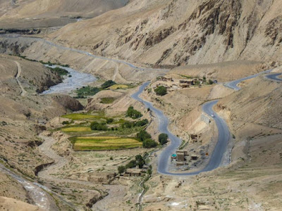
Finally we reach the high point of the day, the second pass at 13,500 feet... all that's left is nearly 15 km of descending at an average gradient of 4%
Destination tonight is Lamayuru
 |
| View from our hotel room window. The monastery is one of the oldest in the region. |
Friday 23 August - 47 km, generally descending - but a couple of steep 150 metre climbs thrown in - for the first 15 km for then generally climbing 200 metres to tonight's destination of Uletopko at a sleeping altitude of 3100 metres, around 10,000 feet.
 |
| both men and women work on the highways, here a female sweeping crew |
This entire region is heavily militarized given the proximity of the border with Pakistan and of disputed territories controlled by China.
Our destination tonight an 'eco lodge' at Uletopko. An apple tree and an apricot tree right outside our door. The apricots were ripe and delicious - all within easy reach. In fact we both ate too many resulting in a few desperate runs to the bathroom the next day.
And finally, for your amusement, some highway signs. The road between Srinagar and Leh is managed by the Border Roads Organisation, hence the term 'BRO' on the signs.


 Finally we reach the high point of the day, the second pass at 13,500 feet... all that's left is nearly 15 km of descending at an average gradient of 4%
 Destination tonight is Lamayuru


 This entire region is heavily militarized given the proximity of the border with Pakistan and of disputed territories controlled by China.
  Our destination tonight an 'eco lodge' at Uletopko. An apple tree and an apricot tree right outside our door. The apricots were ripe and delicious - all within easy reach. In fact we both ate too many resulting in a few desperate runs to the bathroom the next day.
 And finally, for your amusement, some highway signs. The road between Srinagar and Leh is managed by the Border Roads Organisation, hence the term 'BRO' on the signs.


I love those signs! Signs have become a sort of a hobby for me which relates to my work in written communications; I often write about them on my business blog. These really beat everything I have seen before!
ReplyDelete